

The 13th edition brings the biggest route change in years — the loop now stretches east to Ulsoor Lake. Here is the new course, kilometre by kilometre.
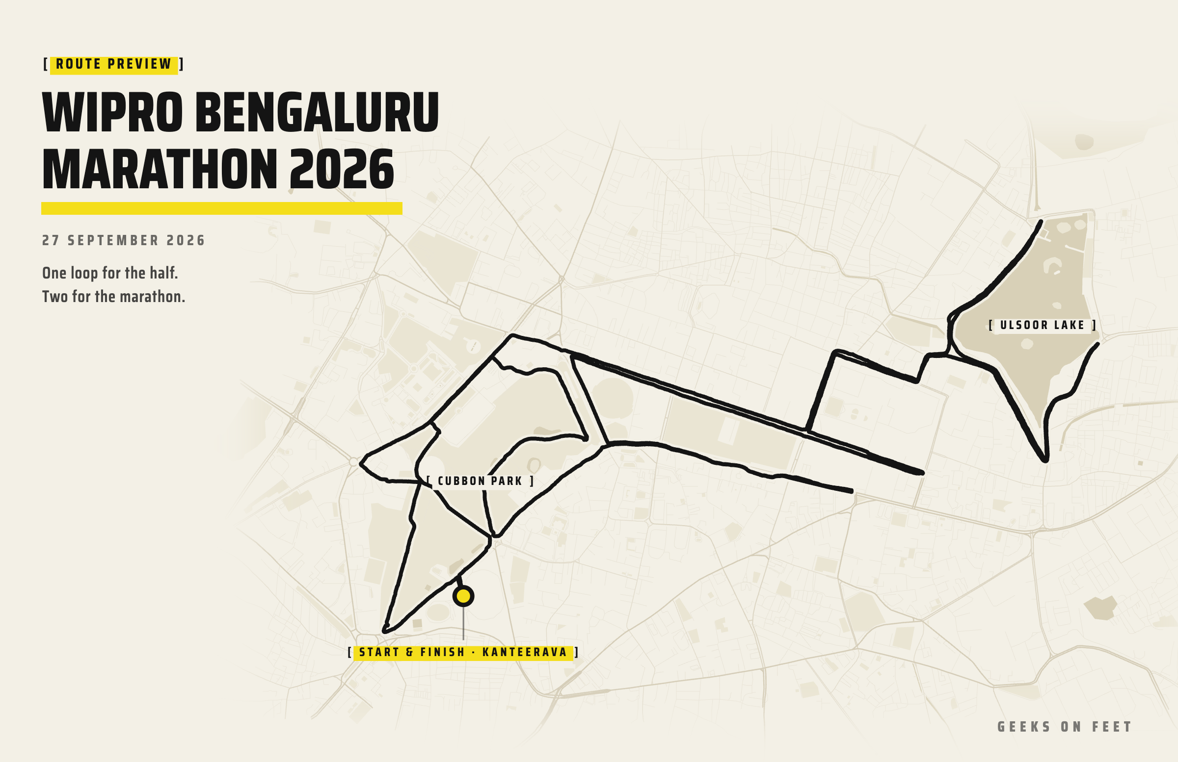
The Bengaluru Marathon turns 13 this year, and for once the answer to “same route as last year?” is no. The organisers have published a new 21.0975 km loop, and it takes the race somewhere it has not been in the recent past — east past Shivaji Nagar and down to Ulsoor Lake.
Half marathoners run the loop once. Marathoners run it twice. Start and finish stay where they have always been, inside Sree Kanteerava Stadium.
The bones are familiar — Kanteerava, Cubbon Park, Vidhana Soudha, MG Road are all still here. But if you ran 2025, throw away your mental map of the middle of the race. The opening three kilometres and the closing stretch through Cubbon Park are much as you remember them. Everything between Minsk Square and Kasturba Road is different.
The early hours of a late-September morning in Bengaluru are usually pleasant; the trouble starts once the sun is up. Expect heavy humidity through the dark hours, around 19–20°C when the marathon goes off, and a post-monsoon sky that can produce either cloud cover or a quick shower. The new eastern half of the course has far less tree cover than Cubbon Park, so the second loop for marathoners will feel warmer than the same clock time did last year.
Our forecast widget below updates through race week — check it the evening before and plan your hydration accordingly.
The holding area is at Kanteerava Stadium, which gives you room to warm up, a 200 m track, baggage counters inside the stadium, enough makeshift restrooms, and a hot breakfast waiting when you are done.
Kanteerava Stadium was originally the Sampangi Stadium, built in 1946, and is named after Sri Kanteerava Narasimharaja Wadiyar, a Mysore royal and sports enthusiast. It was modernised and given its synthetic track in 1997 for the National Games.
The race leaves the stadium through a narrow gate onto the main road. If this is your first time here, start slower than your goal pace — it is congested, and there is a slight rise from the stadium floor up to the road.
Start & Cut-offs
Marathon will be flagged off at 3:50 AM and the half at 6:00 AM in three waves 5 minutes apart. Go by the organisers' final race-day communication, and reach the holding area at least 45 minutes before your start.
Caution
With the marathon starting in the dark, parts of the course are dimly lit — inside Cubbon Park as before, and now also on the lake roads at Ulsoor, which are narrower than CBD roads else where on the course.
There are no hills here, only rollers — but there are more of them than the old course had. From our recording of the route, the loop spans 34 m between its highest point (km 2.8, up by the GPO) and its lowest (km 8.9, on the far side of Ulsoor Lake), and it adds up to 107 m of climbing per lap — 215 m for the marathon. What catches people out is that the rises are long and shallow rather than obvious.
| Kms | Where | Net | What to expect |
|---|---|---|---|
| 0–2 | Kasturba Road, into Cubbon Park | +9 m | You are climbing from the gun. Congested, dark, deceptive |
| 2–3 | K.R. Circle, Dr. Ambedkar Road, GPO, Minsk Square | +8 m | The high point of the course arrives at km 3. Check effort, not pace |
| 4–5 | Cubbon Road EAST, Shivaji Nagar | −23 m | The course tips downhill. Km 5 alone drops 17 m — the fastest kilometre of the day |
| 6–7 | Ulsoor Lake, WEST bank out and back | −5 m | U-turn at the NORTH end. Narrow, two-way running |
| 8 | Lake’s southern tip | flat | Tight hairpin. Slow in, accelerate out |
| 9–10 | Lake’s far bank out and back, then WEST | flat | Second U-turn. Kms 7–10 are the flattest stretch on the course |
| 11–13 | Cubbon Road far end and back | +22 m | Third U-turn, and then three straight kilometres of climbing, all of it gradual |
| 14 | Queens Road, past Chinnaswamy Stadium | +3 m | Still climbing. Short connector down to MG Road |
| 15–16 | MG Road out and back | −2 m | Fourth U-turn. 5 m down to the turn, 3 m back up. The rise home is the sting |
| 17–18 | Kasturba Road, back into Cubbon Park | −7 m | Kasturba Road gives back 9 m into the park. Free speed, take it |
| 19–21 | Cubbon Park to the finish | −2 m | One more 8 m climb at km 19, then 11 m down to the stadium |
Route map — the 21.1 km loop
Kms 0–2: out of the stadium and into the park. Out of the gate, onto Kasturba Road and down past the Indoor Stadium, then a turn NORTH into Cubbon Park. This part is exactly as it has been. The park is 120 hectares and more than 6,000 trees, and it is also full of gentle climbs that do not look like climbs in the dark — our file has you 9 m higher at km 2 than at the start line, which is not what fresh legs and race morning will tell you. Km 1 comes up on the park’s western path, km 2 near K.R. Circle.
Kms 2–3: Vidhana Soudha to Minsk Square. Out of the park at the K.R. Circle end and onto Dr. Ambedkar Road. The road rises for about 500 m here — hold a steady effort rather than a steady pace. Vidhana Soudha is on your left, then the High Court, the General Post Office, and km 3 at Minsk Square. You are now on the roof of the course: nothing in the remaining 18 km is higher than this.
Vidhana Soudha took 5,000 workers four years to build and opened in 1956. Its style borrows from Chalukya, Hoysala and Vijayanagara temple architecture, and the motto “Government Work is God’s Work” is cut into the stone.
Kms 4–5: Cubbon Road and the run EAST. Turn onto Cubbon Road and settle in. This is a long, straight stretch with the Manekshaw Parade Grounds on your right — the first place on the course where you can actually run to a plan. Aid and toilets are marked at km 4. Past the parade grounds the route steps NORTH and heads EAST along the edge of Shivaji Nagar and enter Kamraj Road towards Commercial street. It is tipping downhill the whole way: 6 m of downhill in km #4 and then 17 m of downhill in km #5, which is the steepest kilometre on the course. It will feel like you have found form. You have found gravity — be careful how you pace here, because you climb all of it back between km 11 and km 14.
Kms 6–7: the WEST bank of Ulsoor Lake. You take the Gangadhar Chetty road, and run past the South United Foot Club to enter Annaswamy Mudaliar Road. The lake appears on your right. The course turns up its western edge, runs to a U-turn at the northern tip at Ganapathy temple, and comes back down the same bank. Km 6 is on the way up, km 7 on the way back. The road here is narrower than the main roads and you will have runners coming the other way, so hold your line and keep left.
Ulsoor Lake covers about 50 hectares and is usually credited to Kempe Gowda II in the 16th century, though it was substantially remodelled later. It is one of the few large lakes left in the middle of the city, and most Bengaluru runners have done loops here at some point.
Km 8: the SOUTHERN tip. From the WEST bank the course continues SOUTH-EAST along the lake shore and hairpins at the lake’s southern point - Gurdwara Junction. If you have run TCS World 10K, this stretch is very familiar. This is the tightest turn on the course. Take it wide, do not brake into it.
Kms 9–10: the far bank, then home. Out of the hairpin the route runs up the lake’s eastern side along Bhaskaran Road to a third turnaround — there is an ambulance marked at this one — before coming back and heading WEST on Gangadhar Chetty Road you arrived on. Km 10 is on the way back, and the course’s lowest point sits out here at km 8.9. Kms 7 to 10 are the flattest four kilometres of the day. If you have a goal pace, this is where it is easiest to hold it. Note that the course never makes a full circuit of the lake.
Kms 11–13: the Cubbon Road turnaround. Back at the city end, the route drops back to Cubbon Road (km 11) via Army public school (kamraj road) and continues EAST to its far end, where it turns at about km 12, out by Manipal Centre. Then it is a straight run WEST on Cubbon Road — km 13 goes by with the parade grounds on your left — back towards the GPO. This is the decisive section of the race. Kms 11, 12 and 13 climb 8 m, 7 m and 7 m, and km 14 adds another 3: a 25 m staircase with no flat on it, run into whatever wind there is, on a road that looks dead level. Half marathoners will feel their split slip here. Marathoners on lap two will find out what their first lap cost.
Km 14: Queens Road. Left off Cubbon Road and down Queens Road past the M. Chinnaswamy Stadium. Short, quick, and usually one of the better-supported corners on the course.
Kms 15–16: MG Road. Onto MG Road heading EAST. The road drops 5 m on the way out and takes 3 of them back on the way in, with the turn further EAST than it was in 2025. Km 15 is outbound, km 16 inbound, and the sting is that little rise back towards the Anil Kumble Circle end with 16 km in your legs. If you are going to blow up on this course, this is where it starts.
Kms 17–18: Kasturba Road and back into the park. From the Anil Kumble Circle end you turn down Kasturba Road, which gives back 9 m on the way to the park corner — the one genuinely free stretch late in the loop. Let it run if you are finishing here; keep something back if you are heading out for a second lap. Km 17 puts you on the edge of Cubbon Park, and the tree cover is a relief by now.
Kms 19–21: the park, and the finish. The closing kilometres work back through the park — km 19 at the northern end near the GPO, km 20 over on the western side near Century Club — before the run down to the stadium. There is one last unkindness in km 19, which climbs 8 m back towards the GPO corner. After that it is honest: km 20 is flat and km 21 drops 11 m into the stadium, the biggest descent on the course after km 5. For half marathoners that is the finish line. For marathoners it is the halfway mat, and the start of the real race.
Read it as three acts. You climb for three kilometres, you are given 28 m back over the next three, and then you spend kms 11 to 14 buying them again. The lake kilometres in between are the flattest running of the day.
| Km | Gain (m) | Loss (m) | Net (m) |
|---|---|---|---|
| 1 | 6 | 3 | +3 |
| 2 | 12 | 6 | +6 |
| 3 | 12 | 3 | +9 |
| 4 | 1 | 6 | -5 |
| 5 | 0 | 17 | -17 |
| 6 | 1 | 7 | -6 |
| 7 | 2 | 2 | +0 |
| 8 | 2 | 2 | +0 |
| 9 | 8 | 9 | -1 |
| 10 | 3 | 2 | +1 |
| 11 | 9 | 1 | +8 |
| 12 | 11 | 4 | +7 |
| 13 | 7 | 0 | +7 |
| 14 | 4 | 0 | +4 |
| 15 | 0 | 5 | -5 |
| 16 | 4 | 1 | +3 |
| 17 | 7 | 5 | +2 |
| 18 | 3 | 12 | -9 |
| 19 | 10 | 2 | +8 |
| 20 | 7 | 6 | +1 |
| 21 | 1 | 12 | -11 |
| One loop | 107 | 107 | 0 |
| Marathon | 215 | 215 | 0 |
Per-kilometre figures are rounded to the metre; the totals are taken from the unrounded profile. The table stops at km 21 — the run-in to the line is another 200 m and 4 m of descent.
Download the half marathon GPX — one loop, 21.2 km as measured.
Download the marathon GPX — the same loop run twice, 42.4 km.
Load it into your watch and you can run the second lap knowing where the staircase starts.
Note on GPX file
Kartik ran a slight variation of the half-marathon route on 20 September. Since the official route is published only on 22nd, we had to fill a few linking sections from our past route data. We think this GPX file is practically accurate. So treat the elevation shape as solid and but the absolute altitudes as approximate.
Pacing the race
This is a rolling course that rewards effort-based pacing over even splits, and the 2026 version front-loads the easy running. We have a pace calculator that works off the course profile — use it to put together kilometre splits for your goal time rather than dividing by 21.
Check out the RunStrong pacing calculator here.
You cross the half marathon mark inside the stadium and head straight back out. The familiarity helps, and this year it helps more than usual — the loop has four turnarounds — two at Ulsoor, one at the far end of Cubbon Road, one on MG Road — and knowing exactly where they are is worth real time on the second lap.
Route map — the full marathon, both loops
Three things to plan for.
The sun. The eastern half of the loop has very little shade. Whatever the first loop felt like between kms 5 and 16, the second will be hotter and brighter. Drink at the early aid stations of loop two rather than waiting until you want to.
The traffic. If you are a slow runner, your second loop will run into the half marathon field head-on, most noticeably inside the park, on the narrow lake roads and at the hairpins. Their energy is a lift — use it — but pick your line early and do not spend the race weaving.
The last ten kilometres climb. Everything you gained running down to Ulsoor has to come back, and the file says where: kms 11 to 14, twenty-five metres of it, then one more climb at km 19. Break it up: to the Cubbon Road turn, to Queens Road, up Kasturba Road, into the park. Set small targets and conquer.
The published map is unusually generous, and worth reading before race day.
Your medal comes to you shortly after you cross the line — wear it. Use the space inside the stadium to cool down properly: keep walking, do your stretches, do not sit down straight away. Then find your people, take the photographs, and go and eat the breakfast.
The event works hard on its waste footprint, so do your bit — carry your bottle to a refill point rather than dropping it, and use the bins.
Good luck on Sunday. The route is new, which means everybody’s course PB is up for grabs.


